

|
Select Basin: |
Select Satellite Type: |
Images to Show: |
Space Science & Engineering Center 12 Hour Satellite Loop
Eastern Pacific Area Water Vapor Terrain Map
The above images were produced by the University of Wisconsin Space Science and Engineering Center
Cooperative Institute for Meteorological Satellite Studies

Eastern Pacific
NHC Eastern North Pacific
Eastern North Pacific Tropical Weather Outlook
000ABPZ20 KNHC 012337TWOEP Tropical Weather OutlookNWS National Hurricane Center Miami FL500 PM PDT Tue Jul 1 2025For the eastern and central North Pacific east of 180 longitude:Active Systems:The National Hurricane Center is issuing advisories on Hurricane Flossie, located in the eastern Pacific basin, a couple hundred miles offshore the coast of southwestern Mexico. South of Southwestern Mexico:An area of low pressure is forecast to develop several hundred miles offshore of southwestern Mexico late this week. Environmental conditions appear conducive for some gradual development of this system thereafter, and a tropical depression could form over the weekend while it moves generally west-northwestward.* Formation chance through 48 hours...low...near 0 percent.* Formation chance through 7 days...medium...40 percent. $$Forecaster Jelsema
Hurricane for
Hurricane Flossie
-
Hurricane Flossie Public Advisory Number 12
-
Hurricane Flossie Forecast Advisory Number 12
-
Hurricane Flossie Forecast Discussion Number 12
-
Hurricane Flossie Wind Speed Probabilities Number 12
-
Hurricane Flossie Graphics

5-Day Uncertainty Track last updated Wed, 02 Jul 2025 02:54:02 GMT
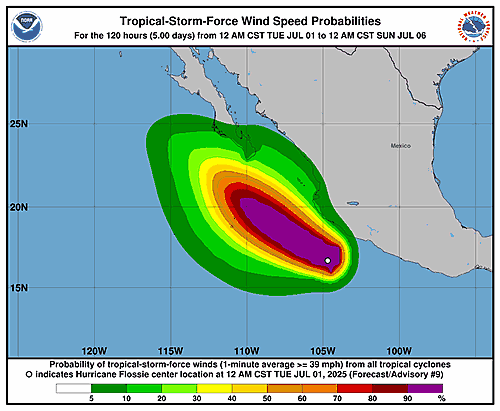
Wind Speed Probabilities last updated Wed, 02 Jul 2025 03:22:10 GMT